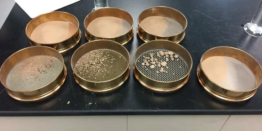
The soil profile shifts markedly between Southampton's central districts and its coastal edges. Around the Itchen waterfront, soft alluvial silts and fine sands dominate, deposited over millennia by the river's tidal reach. Move inland toward Bassett or Highfield and you encounter the Bracklesham Group: dense, sandy clays with intermittent gravel bands. A standard sieve stack alone cannot capture this full spectrum. We run the combined sieve and hydrometer analysis to build a complete particle size distribution curve, from coarse sand down to the 2-micron clay fraction. This dual-stage procedure, calibrated to BS 5930 and BS EN ISO 17892-4, ensures the ground model reflects what the borehole log actually shows. For projects near the container port where dredged fills are common, the hydrometer data often reveals a fines content above 35%, and that number directly shapes the liquefaction assessment under seismic loading scenarios.
A full hydrometer curve reveals the clay fraction that governs both drainage and shrink-swell behaviour in Southampton's London Clay.
Technical details of the service in Southampton
Risks and considerations in Southampton
The Bracklesham and London Clay beds across Southampton contain silt seams and clay lenses that are invisible in a visual log but dominate the mechanical behaviour. A sample described as 'sandy CLAY' might hold 45% silt and only 20% true clay once the hydrometer finishes its run: that difference flips the drainage classification from free-draining to practically impermeable. We have seen projects near the River Test where the contractor assumed a sandy gravel based on the upper sieve curve, but the hydrometer revealed a 28% fines fraction that trapped pore water and delayed earthworks by weeks. BS 5930 classifies such soils as intermediate, and without the full distribution curve the earthworks specification is simply a guess. The combined analysis also identifies frost-susceptible gradations, a genuine concern in Southampton's winter excavations where silty soils can heave and soften after repeated freeze-thaw cycles.
Our services
Every grain size distribution we produce in Southampton feeds into a wider ground investigation framework. These three complementary services reinforce the classification data and deliver the parameters Eurocode 7 demands for design.
Atterberg Limits Determination
Liquid and plastic limits tested to BS 1377-2 on the same fine fraction extracted during your grain size analysis, completing the Casagrande plasticity chart classification.
Moisture Content and Density
Oven-drying and pycnometer methods for natural moisture content and particle density, both required inputs for the hydrometer sedimentation calculation.
SPT Drilling and Sampling
Disturbed and undisturbed sampling via cable percussion or rotary drilling across Southampton, delivering Class 3 to Class 1 samples directly to our lab.
Questions and answers
How much does a full sieve and hydrometer analysis cost in Southampton?
A combined BS 5930 sieve and hydrometer test typically ranges from £90 to £130 per sample, depending on whether the soil requires pre-treatment for organic content or carbonate removal.
How long does the hydrometer sedimentation phase take?
The full sedimentation run takes 24 hours. We record density at ten standard intervals, from 30 seconds through 1440 minutes, plus temperature corrections at each reading.
What is the minimum sample mass needed for a reliable particle size distribution?
BS EN ISO 17892-4 specifies 200 g for predominantly fine soils and 500 g for sandy soils, though we prefer 1 kg when gravel is present to ensure the coarse sieve curve is statistically valid.